THE 7 WALKING TRAILS OF LA MORRA (only for muscular MTB and expert level)
The Association La Morra Eventi e Turismo in collaboration with the Municipality of La Morra has created a network of 7 paths. They cross small wooded areas and admire the great vineyards of Barolo, for a total of about fifty kilometers. These paths, enhancing the historical and cultural heritage of the territory, will let you discover ancient fountains, chapels, rural pillars, botanical areas and panoramic points. Each of them is provided with a specific signpost showing its name, number and color.
Paths n° 2 – 6 – 7 overlook the Langhe del Barolo, Unesco World Heritage site.
Paths n° 3 – 4 – 5 are oriented towards the alpine range and the majestic Monviso.
The project has been realized by Elio Sabena of Trekking in Langa.
N°1 FOOTPATH TO THE LAKE
2,5 km – 40 minutes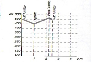
Starting from the Tourist Office, turn towards via XX settembre, cross via San Martino and go down in direction of the medieval bastions. Then turn right through via Marconi, cross via Roma and go down in direction of the small fishing lake, an artificial basin made at the beginning of the 20thc, and the nearby manmade fountain, “Fontana delle cucie”. From here the path climbs through a wood for about 300m to the “Fontana dei Boschi”, fountain of the woods, with a picnic area. It then continues up to the right and joins the main road via Fornace with a fine view over the historic centre of La Morra. Continuing slightly downhill long via Fontane, you reach the little church of Santa Brigida, with XV-century frescoes. From here turn left up towards the town centre, and after about 100m turn right into via Vassali arriving to the “medieval ramparts”, which you then go down through via San Francesco with its magnificent view over the Langa of Barolo, turn left into via Alba to go back and up in direction of the downtown of the village.
N°2 – FOOTPATH OF THE MADONNA DI LORETO
3.7 km – 55 minutes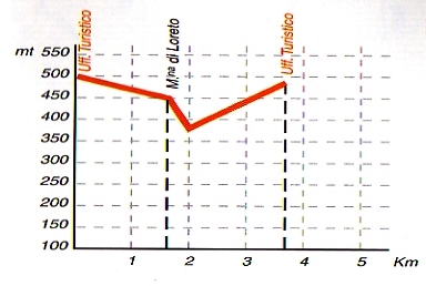 Start out from the Tourist office heading down via Vittorio Emanuele. After the sports grounds turn right onto the surfaced road that becomes a rough path through the vineyards until you reach the Chapel of the Madonna di Loreto, where a scenic stopping point offers a view over the delightful landscape of Alba and the Tanaro valley. The first village you can see on the left of the chapel is Verduno, with the pyramidal dome of the Beata Valfrè Sanctuary. Continue to the right down a steep farm path to the junction where the main road climbs to the right towards the village through vineyards and fields. The view sweeps to the left towards the hills of Grinzane Cavour and Diano d’Alba.
N°3 – FOOTPATH FROM CASTAGNI TO RIVALTA
7.5 km – 1h 50′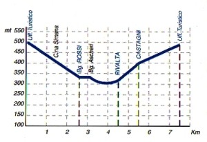 Start out from the Tourist Office. Take via Vittorio Emanuele in the direction of Bra. After about 1.1km turn left for a short section of surfaced road that becomes a dirt path. The Tanaro valley provides an enchanting landscape with the town of Cherasco dominating the centre of the view. The backdrop of the Alps with the peak of Monviso completes the picture. After the characteristic village of Simane, the path rejoins the provincial road for a short stretch, then you turn left down the municipal road. As it approaches the small town of Rossi it bends to the left on a pleasant stretch of flat road between fruit orchards and fields. At Alferi, the path goes down a farm road on the right to the village of Ascheri. Following this slight ascent, you come to Rivalta. Joining the municipal road again, head towards Rossi, and after about 100m turn up to the left until you reach the village of Castagni,. Follow directions for the Chapel of the Madonna di Loreto: the panorama opens to the left onto Diano, Alba and Grinzane Cavour, and towards the right, the hills of Castiglione Falletto. Head back towards La Morra on the rough road first through Nebbiolo vineyards and then along the crest, until you reach the sports grounds. The last uphill stretch of road leads back into the town.
N°4 - FOOTPATH OF SANT’ANNA
8 km – 2 h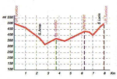
Start out from the Tourist Office. Take via Vittorio Emanuele. After about 1km turn left onto the dirt path. The view opens magnificently over the Tanaro Valley and the town of Cherasco. In the distance the chain of the Alps forms a backdrop dominated by the peak of Monviso. The road proceeds through hazelnut orchards and fields as far as Mascarelli. After joining the provincial road for about 50m, turn right onto the rough path through the hazelnut groves, to the country chapel of Sant’Anna, which commands a fine view of the vineyards. Continue along the vineyards for about 100m, turn left, go down until the winery and join the provincial road. Follow the road downhill to the right for about 50m then turn left onto the farm path into the thriving hazelnut grove, between orchards and vineyards. From this path between the fields you can admire the view of the Tanaro Valley on your right until you reach the asphalt road on the crest of the hill. Turn left through the small village of Merlotti and Brandini and skirting the vineyards you will see the town of La Morra on your right. To the left there is a sweeping view of the villages of the Roero district: Pocapaglia, Santa Vittoria and Ponticello, with a glimpse of the mass of Monte Bianco in the far distance. Go down to the right on the farm path towards the valley of the Brandini stream, cross it and follow the path up through the woods and reaching the little church of Santa Lucia. Then turn right towards the downtown of the village.
N°5 – FOOTPATH OF WIDE HORIZONS
5,8 km – 1h 45′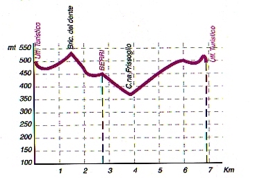
Start out from the Tourist Office, taking via Roma as far as the little church of Sante Brigida; just after it turns left on the footpath and then the road as far as Bricco del Dente. The great circular panorama offers a bird’s-eye view. The path goes down among vineyards and shady woods on the rough path towards the Berri stream, in a very evocative and natural setting full of native species of flora and fauna. You arrive to the Chapel of S. Antonio on the outskirts of the hamlet of Berri. From here, proceed on the right downhill, with the view sweeping before you over the valley of the Tanaro: the town of Cherasco in the foreground and a breathtaking landscape behind, the chain of the Alps dominated by the perfect silhouette of Monviso. The path leads gently down between meadows, vineyards and orchards then climbs up again along the dirt road until via Fornace, then turn left and follow the paved road to reach the start of the village into via Roma.
N°6 – FOOTPATH OF THE GRAND VINEYARDS
8 km – 2 h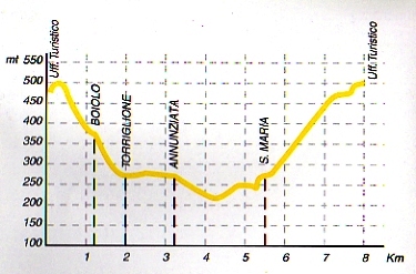 From the Tourist Office go up to piazza Castello: from here a panorama encompasses the Barolo vine estates and the grand crus. A short section of the walk goes through the village, past the municipal winery, the Town Hall and the fine, imposing façade of San Martino. It follows the medieval ramparts downhill. Turn to the left into via Vassali, turn left in via Roma and then to the cross follow strada Fontanazza onto a surfaced road which then becomes a rough path, the view opens broadly onto the most celebrated valley of Barolo. After a short stretch, turn left on the field path that leads to the village of Boiolo. Proceed downhill to the base of the valley, through Torriglione where an ancient Mulberry tree can be found. Passing between noble vineyards you come to the hamlet of Annunziata; go on along the surfaced road, borgata Ciotto then the dirt path, as far as Santa Maria, with its 19thC church. The walk continues briefly on the provincial road then, you arrive to the modern red bench, turns up to the right on a dirt path among the nebbiolo vines until it reaches the last asphalted section of road into the town.
N°7 – FOOTPATH OF THE BAROLO
11,5 km – 3h 15′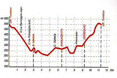 From the Tourist Office set off downhill in the direction of Alba. Turn right onto a path which joins the provincial road below. Take the local road to the left which goes down to the valley. The view opens out onto a spectacular horizon: to the left the Roero hills, in the centre the town of Roddi dominated by the castle, then the vineyards of Barolo fanning out on the right. The walk continues downhill on a field path, passing close to a farmstead, then rejoins the asphalt road as far as the houses of Santa Maria, dominated by the church perched on the highest point of the hill. It continues among the vineyards of the famous wine labels, as far as Annunziata, where you can see on the left, soaring on its perfect hilltop, the great cedar of Lebanon that was planted by the Falletti family in 1875. The beauty of the whole landscape at this point makes it one of the most photographed sights. The village church, SS. Annunziata, has a Romanesque bell-tower, 18thC frescoes inside and an inscribed Roman headstone imbedded in the paving: it once belonged to the ancient Benedictine convent of Marcenasco, the central body of which is still standing, as part of the Museo Ratti, museum of Alba wines. The path continues between the ordered rows of vines towards the hamlet of Fontanazza; the chapel here, “Cappella del Barolo”, stands with its façade facing the cru of the Brunate. The trail then leads to Cerequio, where a memorial is dedicated to the partisans shot during the Second World War. A steep path takes you back in direction of La Morra village. You follow the old bastions way and then you arrive to Cantina Comunale where you can have a Barolo tasting with Barolo grapes that come from the best crus of Barolo you just go through.
The most prestigious vineyards for Barolo wine that you can observe long your walk are La Serra, Cerequio , Fossati, Case Nere, Rocche dell’Annunziata, Giachini , Bricco Rocca, Bricco Luciani, Gattera, Manescotto, Manzoni, San Biagio, Capalot, Roggeri, Rocchettevino, Galina, Bricco Chiesa, Sarmassa , Bettolotti, Roere, Ciocchinie Roncaglie.
MTB routes available by contacting info@lamorraturismo.it